Wow, what a few days we just had; hiking, biking, and horses. We started in Quito, Ecuador, then headed south to Cotopaxi National Park. What makes it even better is that we have been so looking forward to relaxing on the beach in Mexico that we sort of overlooked this part of the trip, and I totally underestimated how awesome this part of Ecuador is. Ecuador is amazing because for such a small country, it has greatly diverse geography. We already wrote about the Galapagos Islands, and in addition to the coastal areas, there are huge Andean peaks and Amazon rain forests. By the time we leave, we will have hit it all.
After the Galapagos, we spent two nights in Quito, the capital of Ecuador and the highest official capital in the world (if you read the La Paz blog, you may remember that it is higher, but only the functional, and not the official capital of Bolivia). I didn't love Quito, for that matter, I haven't loved any of the big cities in South America. Just like in all the other cities, we kept getting reminded how dangerous they are and not to carry valuables with you or to walk alone after dark. We have seen our share of gaudy churches and Spanish colonial architecture at this point as well. However, we did learn a few interesting things on our free walking tour of the city. As its name implies, Ecuador lies on the equator, which means the temperature and weather doesn't change much throughout the year. Also, things grow well due to all the sun, so it is no surprise that Ecuador is a large exporter of tropical fruit and flowers. Being on the equator also gives a unique solar perspective, and adding the high peaks of the Andes, provides fixed landmarks against which to observe the sky. This is one of the reasons why the prehistoric people of Ecuador were such great astronomers.
Ecuador didn't gain its independence from Spain directly. About 1820, a country called Gran Colombia was able to break away from Spanish rule. This country then split into Ecuador, Colombia, and Venezuela (as well as parts of other nearby nations) about 10 years later. These three countries still have very similar flags to Gran Colombia with horizontal bands of yellow, blue, and red differing only by the coat of arms in the middle.
Very similar to an episode of recent Bolivian history, Ecuador had a president who allegedly stole millions of dollars from the country, then fled to... guess where... yes, the United States of America. Jamil Mahuad was in office during a financial crisis and had to evacuate after a military coup in 2000. What exactly went down, I don't know, but our tour guide seemed to think that Mahuad was personally responsible for the crisis by his theft. He is still living freely in the U.S. while there is an arrest warrant for embezzlement in his home country. Ironically, according to Wikipedia, he lectures in ethics at several universities in the U.S.. The best part of our time in Quito was that our good friend Maureen met up with us. This was the third time we have seen her on our trip!
We were excited to leave the city and explore some of the less crowded parts of the country. We hopped on a bus to Machachi for a $1.30 each and a 45 minute ride. To our surprise, there is no bus station in Machachi, so the bus dropped us off on the side of the highway. From here we were supposed to take a "pickup truck taxi" to the hotel, so we started to walk towards the town in hopes of finding one. Luckily, it didn't take long to spot a truck that appeared to also be a taxi, so we asked for a ride to our hotel. I hopped in the bed along with our bags while Mo and Jesslyn squeezed into the cab with the driver. After a very rough (now I know why the taxis are 4WD pickup trucks) 30 minute ride through the beautiful countryside, we arrived at La Hacienda Mortiños, just outside the north gate of Cotopaxi National Park. The park is home to a picturesque, perfectly conical, snow-capped volcano of the same name which is the second highest point in all of Ecuador at 19,347 feet. Hiking the volcano is not allowed at the moment because of some supposed rumblings, and for the same reason much of the park is closed. The owner of the hacienda said that the volcano hasn't actually been active, but the closure is instead due to political reasons. Once again, who knows the true story?
Although much lower, another prominent peak in the park is the jagged and rocky Rumiñahui. There is no snow on the peak, and doesn't require any technical experience nor gear, so we decided to make of go of it. Even though it is not "technical", it is still difficult (for us anyway!), mostly due to the elevation. The hike starts at 12,400 feet, and we attempted the south peak which tops out at 15,400 feet. As the trail got steeper and steeper, we had to stop and catch our breath every 10 steps or so. It also didn't help that the trail is not marked... at all. So we ended up backtracking a couple of times when we realized we missed a turn. Mo decided she had had enough part way through the hike and we agreed to meet up with her on our way back down. As the trail turned into very steep, loose scree, we found ourselves scrambling with our arms and hands. Then it started to rain, which quickly turned to sleet and snow causing the already loose footing to be slippery. At that point, Jesslyn decided she had had enough. I left my pack with Jesslyn and pushed on because the peak appeared to be only about another 10 minutes away. Just before the summit, it turned into a bit of a rock climb, but luckily it wasn't too difficult. I reached the very top, greeted by zero visibility and incredibly strong wind which sucked more than normal because the peak is just a sharp, jagged rock with very little room to stand. The wind was a serious threat to knock me off my perch. Needless to say, I didn't stick around very long before heading back down. This was nothing like the rounded mountain tops of the Appalachians.

This view of Cotopaxi is from the property of the hacienda with our llama buddy posing in the foreground.

Jesslyn posing in front of the peak of Ramiñahui. I summited the southern peak to the left.
We started the next day with a three hour horseback ride, leaving right from the hacienda and making a giant loop inside the park. This was my fourth time on a horse, and I love it. While you have some control over the animal, they have a mind of their own and ultimately do what they want. On the way out, my horse lagged behind requiring many kicks and clucks from me to get it to keep up with the others and I had to steer it since it didn't seem to want to follow. However, on the way back, it led the pack, including our guide. Since the horse knows where home is, I didn't have to steer much. I kind of felt bad, like he didn't want to be out there. I guess I wouldn't care to have 180 pounds on by back for three hours either. The ride was incredible because of the scenery which was made better by the unusually clear skies. We saw enormous condors for the first time ever, soaring high above as as the great Cotopaxi towered over us. As we rode across the rocky landscape surrounded by mountains, I felt like a cowboy traipsing across Montana in the 1800's. As wonderful as it was, three hours is more than enough time in a saddle for me. That afternoon I set out for the park again, this time on a mountain bike. Unfortunately, the weather turned on me, so it was a short two hour ride, but I was able to get a few pics of some of the wild horses in the park.
It was great to be out in the countryside of Ecuador, surrounded by stunning natural beauty. I was also happy to get a lot of exercise and well as some R & R. After just three short nights, we were off again. Next stop Latacunga and the nearby Quilotoa crater lake.
- Jake
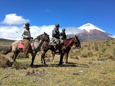
Pretending to be cowboys.

These are horses on the property of the hacienda.